BRAND NEW GHOST TOWNS OF...
documentary, location research
2011
LOCATIONS - Rio Vista, CA
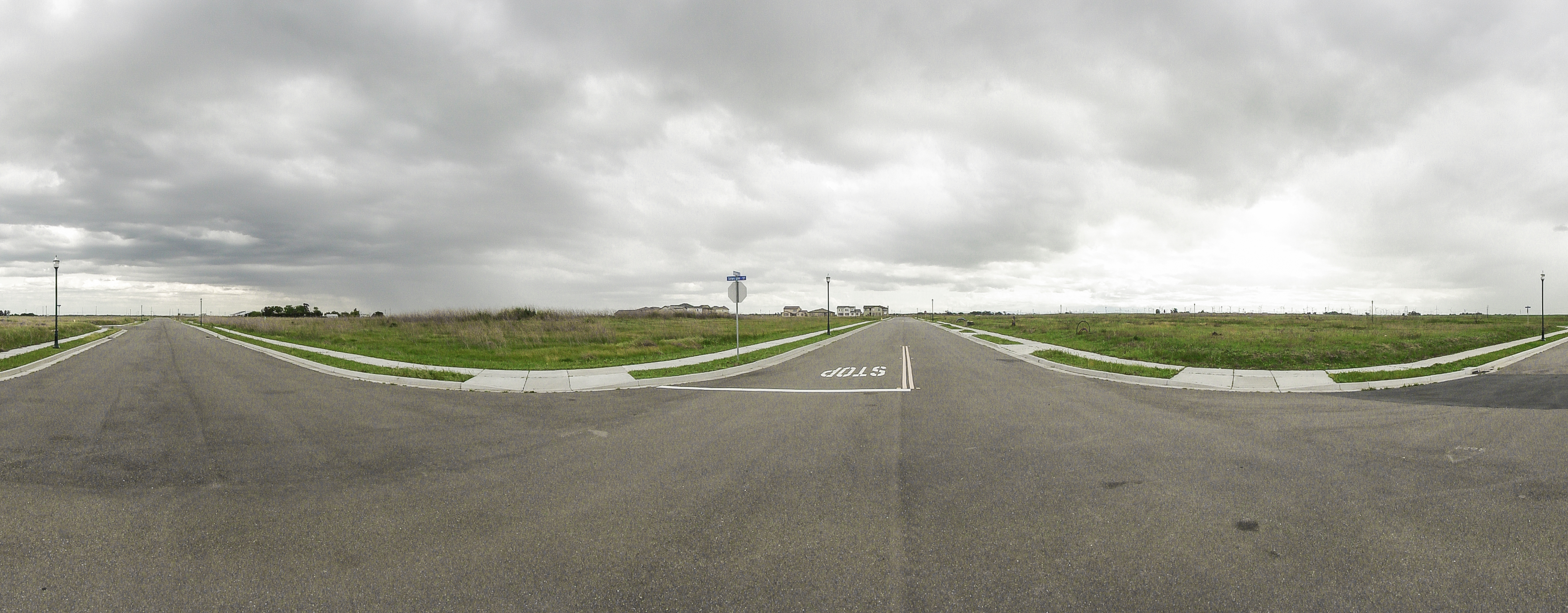
1/2 - ‘Brand new Ghost Town’ of Rio Vista, CA
[Uninhabited/failed exuburban development with
completed infrastructure, street signs and lamp posts,
located in the Sacramento River Delta, near Antioch
38° 11‘ 55.28“ N, 121° 43‘ 04.57“ W
elev 2-17 m - April 2011]
1/2 - ‘Brand new Ghost Town’ of Rio Vista, CA
[Uninhabited/failed exuburban development with
completed infrastructure, street signs and lamp posts,
located in the Sacramento River Delta, near Antioch
38° 11‘ 55.28“ N, 121° 43‘ 04.57“ W
elev 2-17 m - April 2011]

2/2 - Roads end in ‘downtown’ Rio Vista, CA

Rio Vista, CA (1993)
Historic satellite image of the later site of Rio Vista, CA
38° 11‘ 55.28“ N, 121° 43‘ 04.57“ W
Imagery date 16-06-1993
Eye altitude 1,51 km - (c) GoogleEarth
Historic satellite image of the later site of Rio Vista, CA
38° 11‘ 55.28“ N, 121° 43‘ 04.57“ W
Imagery date 16-06-1993
Eye altitude 1,51 km - (c) GoogleEarth
Rio Vista, CA (2006)
Historic satellite image of Rio Vista, CA (under construction)
38° 11‘ 55.28“ N, 121° 43‘ 04.57“ W
Imagery date 10-08-2006
Eye altitude 857 m - (c) GoogleEarth
Historic satellite image of Rio Vista, CA (under construction)
38° 11‘ 55.28“ N, 121° 43‘ 04.57“ W
Imagery date 10-08-2006
Eye altitude 857 m - (c) GoogleEarth
Rio Vista, CA (2007)
Historic satellite image of Rio Vista, CA 38° 11‘ 55.28“ N, 121° 43‘ 04.57“ W
Imagery date 01-06-2007
Eye altitude 528 m - (c) GoogleEarth
Historic satellite image of Rio Vista, CA 38° 11‘ 55.28“ N, 121° 43‘ 04.57“ W
Imagery date 01-06-2007
Eye altitude 528 m - (c) GoogleEarth
Rio Vista, CA (2009)
Historic satellite image of Rio Vista, CA
38° 11‘ 55.28“ N, 121° 43‘ 04.57“ W
Imagery date 24-09-2009
Eye altitude 426 m - (c) GoogleEarth
Historic satellite image of Rio Vista, CA
38° 11‘ 55.28“ N, 121° 43‘ 04.57“ W
Imagery date 24-09-2009
Eye altitude 426 m - (c) GoogleEarth

Rio Vista, CA (2010)
Satellite image of Rio Vista, CA
38° 11‘ 55.28“ N, 121° 43‘ 04.57“ W
Imagery date 04-07-2010
Eye altitude 2,9 km - (c) GoogleEarth
Satellite image of Rio Vista, CA
38° 11‘ 55.28“ N, 121° 43‘ 04.57“ W
Imagery date 04-07-2010
Eye altitude 2,9 km - (c) GoogleEarth

Rio Vista, CA (2010)
Satellite image (zoom) of Rio Vista, CA
38° 11‘ 55.28“ N, 121° 43‘ 04.57“ W
Imagery date 04-07-2010
Eye altitude 488 m - (c) GoogleEarth
Satellite image (zoom) of Rio Vista, CA
38° 11‘ 55.28“ N, 121° 43‘ 04.57“ W
Imagery date 04-07-2010
Eye altitude 488 m - (c) GoogleEarth

Rio Vista, CA (2010)
Satellite image (zoom) of Rio Vista, CA
38° 11‘ 55.28“ N, 121° 43‘ 04.57“ W
Imagery date 31-10-2011
Eye altitude 194 m - (c) GoogleEarth
Satellite image (zoom) of Rio Vista, CA
38° 11‘ 55.28“ N, 121° 43‘ 04.57“ W
Imagery date 31-10-2011
Eye altitude 194 m - (c) GoogleEarth


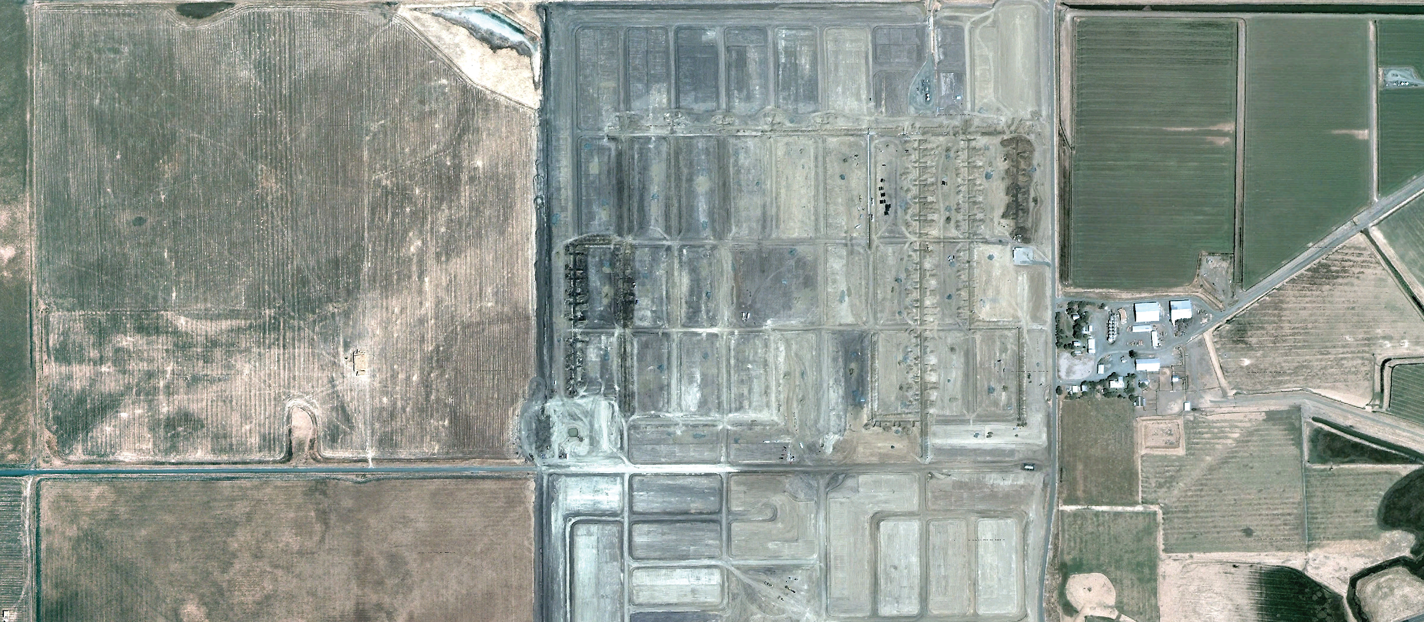
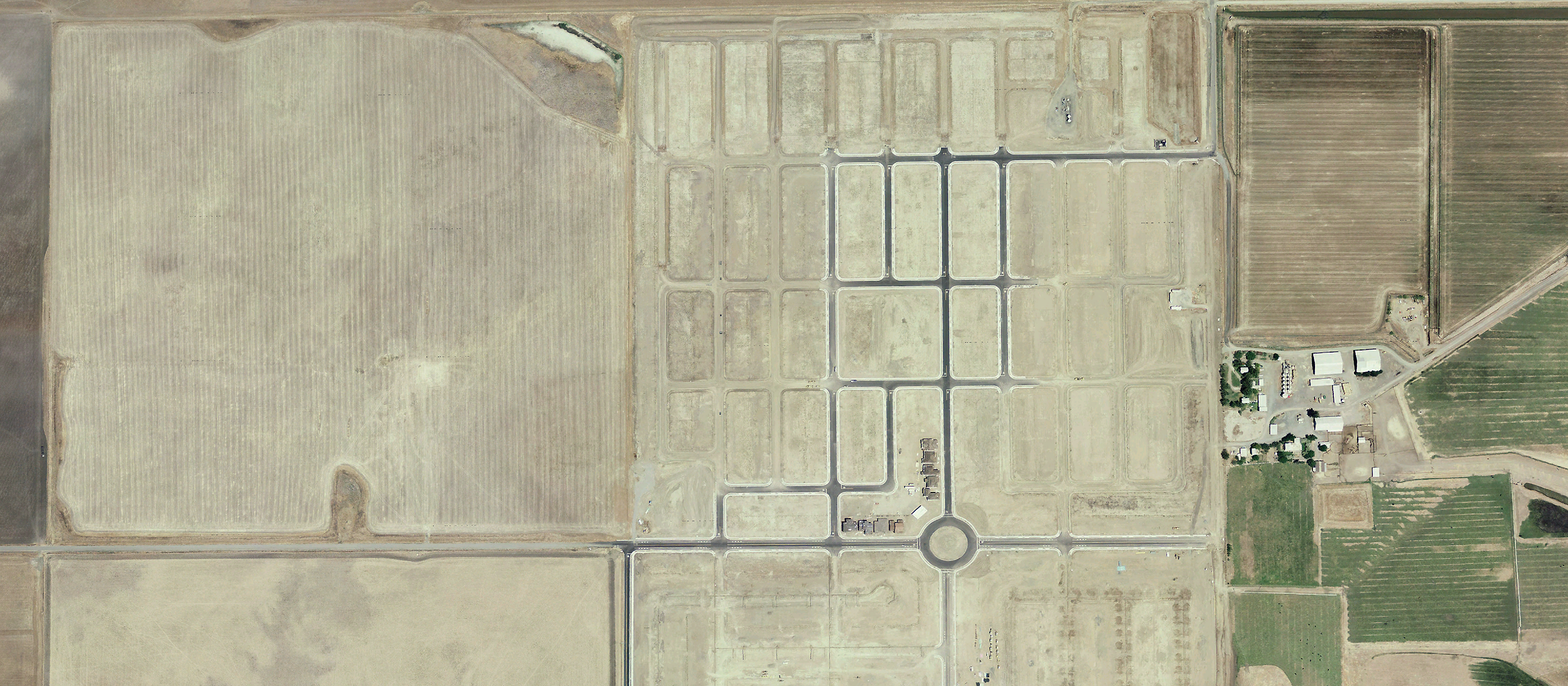
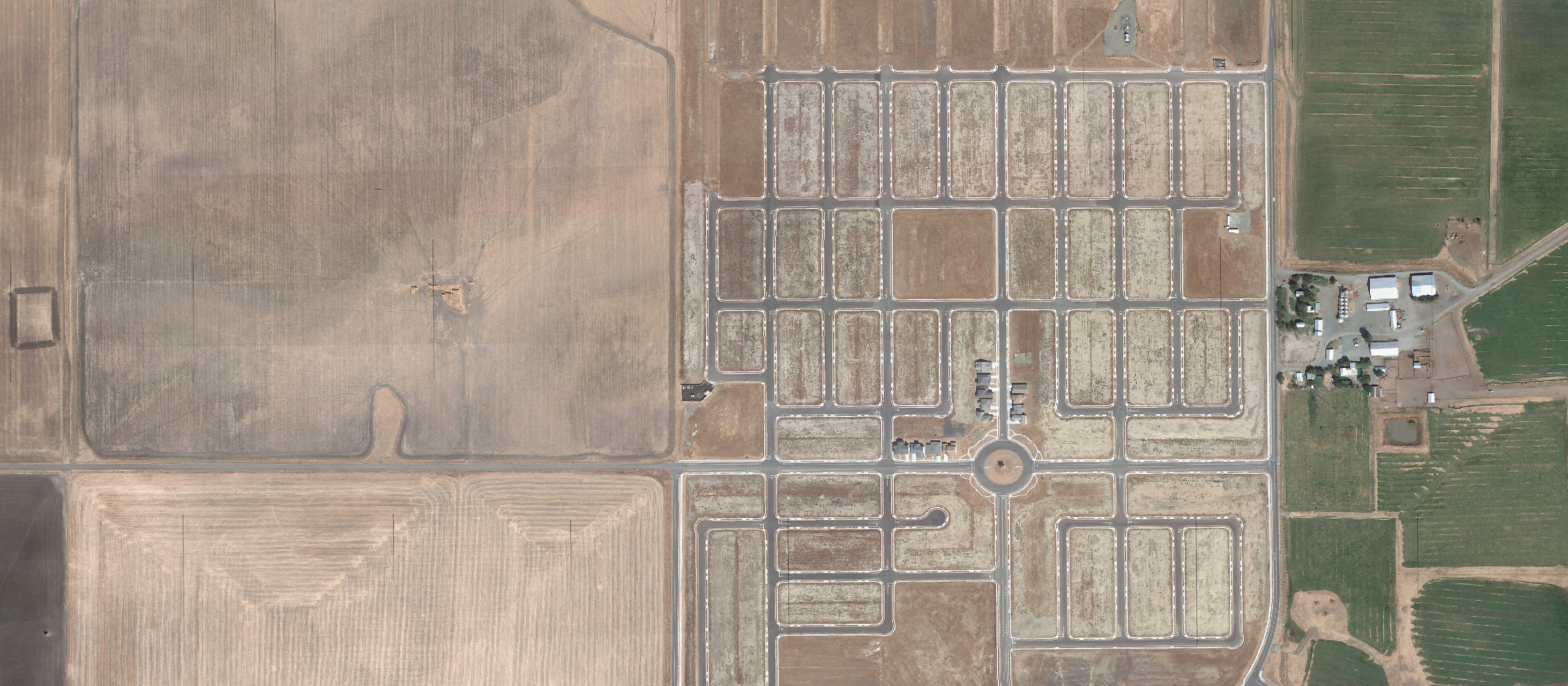
LOCATIONS - California City, CA
1-3/5 - ‘Ghost Developments’ of California City, California, USA
[City layout gridded out in the desert (planned size comparable to Greater Metropolitan Area of Los Angeles)
located in the Mojave Desert, near Boron
35° 11‘ 05.46“ N, 117° 47‘ 27.64“ W
elev 790 - 975 m - May 2011]
1-3/5 - ‘Ghost Developments’ of California City, California, USA
[City layout gridded out in the desert (planned size comparable to Greater Metropolitan Area of Los Angeles)
located in the Mojave Desert, near Boron
35° 11‘ 05.46“ N, 117° 47‘ 27.64“ W
elev 790 - 975 m - May 2011]
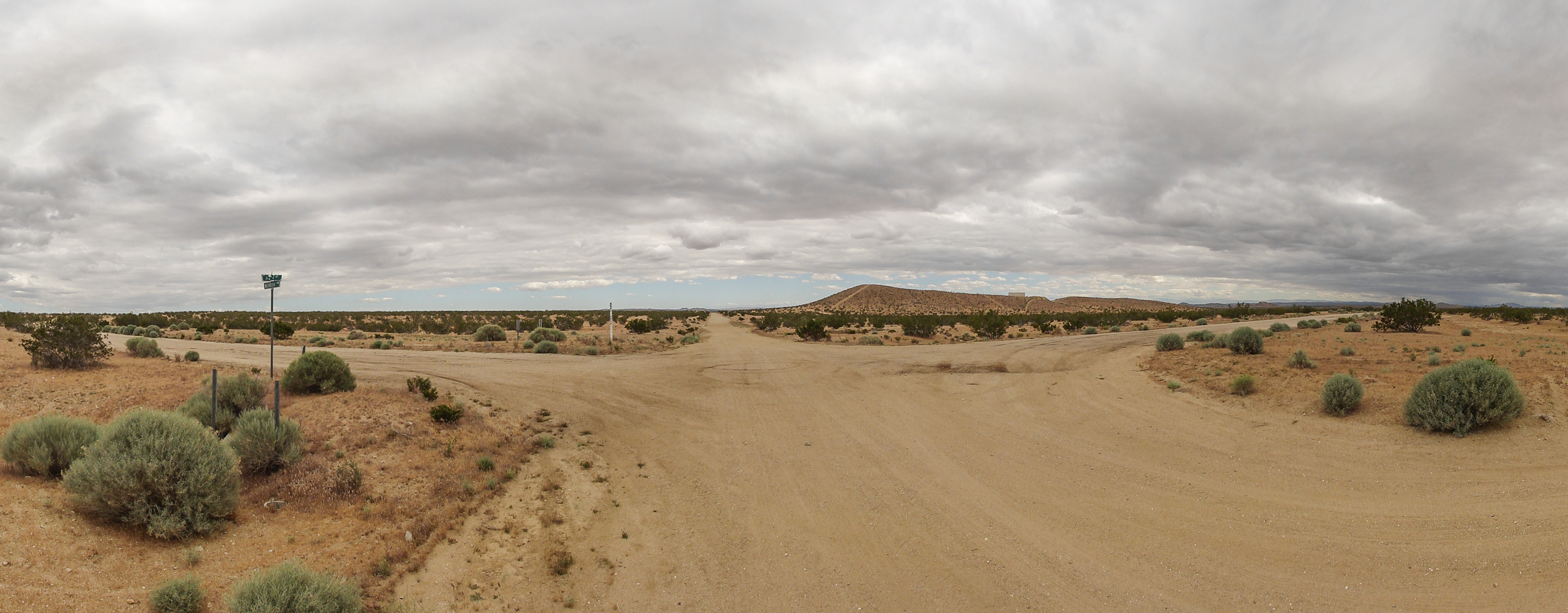
4/5 - Junction of named dirt-roads (‘Cadillac Ave’ & ‘Hans Blvd’),
California City, CA
35° 11‘ 24.88“ N, 117° 46‘ 41.374“ W elev 869 m - May 2011
California City, CA
35° 11‘ 24.88“ N, 117° 46‘ 41.374“ W elev 869 m - May 2011

California City, CA (2005)
Satellite image of California City, CA
35° 11‘ 05.46“ N, 117° 47‘ 27.64“ W
Imagery date 31-12-2005
Eye altitude 3.07 km - (c) GoogleEarth
Satellite image of California City, CA
35° 11‘ 05.46“ N, 117° 47‘ 27.64“ W
Imagery date 31-12-2005
Eye altitude 3.07 km - (c) GoogleEarth
Satellite image of California City, CA (detail)
35° 11‘ 24.88“ N, 117° 46‘ 41.374“ W
Imagery date 31-12-2005
Eye altitude 1.57 km - (c) GoogleEarth
35° 11‘ 24.88“ N, 117° 46‘ 41.374“ W
Imagery date 31-12-2005
Eye altitude 1.57 km - (c) GoogleEarth

5/5 - Named/numbered streets in the desert - near Salton City, CA
SCREENPLAY - Live Performance & GPS-Voice-Over
[GoogleMaps directions as a ready-made script for live performance inside the car installation - and as a route planner for getting lost.]
[GoogleMaps directions as a ready-made script for live performance inside the car installation - and as a route planner for getting lost.]

1/5 - Route 1 - Rio Vista, CA
[Driving directions through Rio Vista, CA - Screencapture (c) GoogleMaps]
[Driving directions through Rio Vista, CA - Screencapture (c) GoogleMaps]
Screenplay outtakes [orig.: engl./ger.]:
(Stimme aus dem Off - Ansagen des Navigationssystems aus den knackenden, teilweise aussetzenden Lautsprechern des alten Autoradios - live improvisiert von einer Sprecherin auf dem Rücksitz)
“Please enter your means of transportation:
A … car
B… transit
C … by foot
D … bycycle
Thank you!
Please keep in mind:
These directions are for planning purposes only. You may find that construction projects, traffic, weather, or other events may cause conditions to differ from the map results, and you should plan your route accordingly. You must obey all signs or notices regarding your route.
Map data ©2011 Google”
(Verschiedene Handzettel für verschiedene Verkehrsmittel, überfordertes Suchen nach dem richtigen Zettel, GPS verliert den Überblick, aber nicht die Geduld, verwirrtes Herumhantieren mit all den viel zu vielen Zetteln und Suchen nach dem richtigen.)
RIO VISTA - Route 1
“Driving directions to Liberty Island Rd, Rio Vista, CA
- more info >>
...“
[see screencapture 1 of 5]

2/5 - Route 1 - Rio Vista, CA
[Walking directions through Rio Vista, CA - Screencapture (c) GoogleMaps]
[Walking directions through Rio Vista, CA - Screencapture (c) GoogleMaps]
“...
Search for Transit directions to Liberty Island Rd, Rio Vista, CA:
Your search for transit directions from McCormack Rd, Rio Vista, CA 94571 to Liberty Island Rd, Rio Vista, CA appears to be outside our current coverage area. Please consult our list of participating public transit agencies.
Get driving directions from McCormack Rd, Rio Vista, CA 94571 to Liberty Island Rd, Rio Vista, CA. --
Walking directions to Liberty Island Rd, Rio Vista, CA:
(A) McCormack Rd, Rio Vista, CA 94571
1. Head east on McCormack Rd toward Canright Rd
2.3 mi
2. At the traffic circle, take the 1st exit
0.2 mi
3. Turn right 0.1 mi
4. Turn left toward Liberty Island Rd 492 ft
5. Turn right toward Liberty Island Rd 0.2 mi
6. Turn right toward Liberty Island Rd 171 ft
7. Turn left onto Liberty Island Rd
3.4 mi
(B) Liberty Island Rd, Rio Vista, CA 3.7 mi, 1h 10 mins total
...”
[also refer to screencapture 2 of 5]
...”

3/5 - Route 1 - Rio Vista, CA
[Bicycling directions through Rio Vista, CA - Screencapture (c) GoogleMaps]
[Bicycling directions through Rio Vista, CA - Screencapture (c) GoogleMaps]
“...
Bicycling directions to Liberty Island Rd, Rio Vista, CA :
(A) McCormack Rd, Rio Vista, CA 94571
1. Head east on McCormack Rd toward Canright Rd
--
GPS beginnt angesichts des Ortes langsam zu kapitulieren:
You are entering a dead end street – (abbiegen) you are entering a dead end street, attention, this street does not continue/ends in 300 yards – please turn around - (abbiegen) – you are entering a dead end street, no outlet in this direction – there is an outlet to your right, south of here – (links abbiegen) – this was not right, this was a left turn, this was a left turn, caution, you are entering a dead end street, there is “no outlet” (Einfügung von voraufgenommenen Sprachfetzen) anymore in “all directions”, caution, there are dead-end streets in all directions ahead … Please turn around immediately – caution, U-turn is not allowed here - … (setzt fort sich in einen Wirbel zu reden)
Bei deliriösen Kreisfahrten in der All-way-Stop Kreuzung:
This is not the right way, please turn around. -- Wrong way, wrong way – wrong’ wrong way, the destination you entered is in the other direction/behind you. -- Turn around. Please turn’ turn around, turn around here. (U-turn not allowed here)’ Turn around.
Please turn right’, sorry, turn left here. -- I am very sorry for my mistake. I normally don´t do that. Making mistakes. Sorry.
(ev. Systemabsturz aufgrund eines Ausnahmefehlers)
Shutting down due to an unknown exception.
Beim Überfahren der Stoptafeln:
This is, ah, this was an All-way Stop sign.
There is a fire hydrant to your right, the next fire hydrant is coming up to your left in 500 yards.
May I bring to your attention that the road is not continuing here. Please turn. This is a dead end.
This is the suburb of Rio Vista, this is a grid of dead-end streets.
Your destination is right behind you.“
Bicycling directions to Liberty Island Rd, Rio Vista, CA :
(A) McCormack Rd, Rio Vista, CA 94571
1. Head east on McCormack Rd toward Canright Rd
2.1 mi
2. Turn left 289 ft
3. Turn right 243 ft
4. Turn left 0.3 mi
5. Turn right 0.4 mi
6. Turn left 2.8 mi
7. Keep right at the fork 0.6 mi
(B) Liberty Island Rd, Rio Vista, CA
3.7 mi, 17 mins total
--
GPS beginnt angesichts des Ortes langsam zu kapitulieren:
You are entering a dead end street – (abbiegen) you are entering a dead end street, attention, this street does not continue/ends in 300 yards – please turn around - (abbiegen) – you are entering a dead end street, no outlet in this direction – there is an outlet to your right, south of here – (links abbiegen) – this was not right, this was a left turn, this was a left turn, caution, you are entering a dead end street, there is “no outlet” (Einfügung von voraufgenommenen Sprachfetzen) anymore in “all directions”, caution, there are dead-end streets in all directions ahead … Please turn around immediately – caution, U-turn is not allowed here - … (setzt fort sich in einen Wirbel zu reden)
Bei deliriösen Kreisfahrten in der All-way-Stop Kreuzung:
This is not the right way, please turn around. -- Wrong way, wrong way – wrong’ wrong way, the destination you entered is in the other direction/behind you. -- Turn around. Please turn’ turn around, turn around here. (U-turn not allowed here)’ Turn around.
Please turn right’, sorry, turn left here. -- I am very sorry for my mistake. I normally don´t do that. Making mistakes. Sorry.
(ev. Systemabsturz aufgrund eines Ausnahmefehlers)
Shutting down due to an unknown exception.
Beim Überfahren der Stoptafeln:
This is, ah, this was an All-way Stop sign.
There is a fire hydrant to your right, the next fire hydrant is coming up to your left in 500 yards.
May I bring to your attention that the road is not continuing here. Please turn. This is a dead end.
This is the suburb of Rio Vista, this is a grid of dead-end streets.
Your destination is right behind you.“
4a/5 -
Google Maps-coverage of a non-exisiting city
[Directions for cruising California City, CA - Screencapture (c) GoogleMaps]
[Directions for cruising California City, CA - Screencapture (c) GoogleMaps]
CALIFORNIA CITY Cruising – Route 2
“Driving directions to Amparo Way, California City, CA :
(A) Vande Way, California City, CA 93505
1. Head east on Vande Way toward Barker St
3b. all the way up to Alamo Dr
3c. do not leave Hans Blvd by all means, despite you want to get lost completely
3d. this is a field-guide to getting lost
3e. or a field-trip into the nearest nowhere
3f. for properly losing your way, stay on Hans Blvd
3g. through the neighborhood of SoHa (South-of-Hans)
3h. there you go
(B) Heidi Ct, California City, CA
8. Head south on Heidi Ct toward Heidi Dr
“Driving directions to Amparo Way, California City, CA :
(A) Vande Way, California City, CA 93505
1. Head east on Vande Way toward Barker St
299 ft
2. Turn left onto Barker St 0.1 mi
3. Turn right onto Hans Blvd
3a. Follow/Stay on Hans Blvd for the next 1.3 miles 3b. all the way up to Alamo Dr
3c. do not leave Hans Blvd by all means, despite you want to get lost completely
3d. this is a field-guide to getting lost
3e. or a field-trip into the nearest nowhere
3f. for properly losing your way, stay on Hans Blvd
3g. through the neighborhood of SoHa (South-of-Hans)
3h. there you go
1.4 mi
4. Turn left onto Alamo Dr 0.3 mi
5. Take the 2nd left onto Caspio St 440 ft
6. Take the 1st right onto Heidi Dr 351 ft
7. Take the 1st left onto Heidi Ct 226 ft
2.0 mi – about 9 mins
2.0 mi – about 9 mins
(B) Heidi Ct, California City, CA
8. Head south on Heidi Ct toward Heidi Dr
226 ft
9. Turn left onto Heidi Dr 0.3 mi
10. Take the 3rd left onto Lincoln Blvd 0.2 mi
11. Take the 2nd right onto Rudnick Blvd 0.7 mi
12. Turn left onto Vercye St 0.4 mi
1.6 mi – about 7 mins”
[continued on page 5]
1.6 mi – about 7 mins”
[continued on page 5]

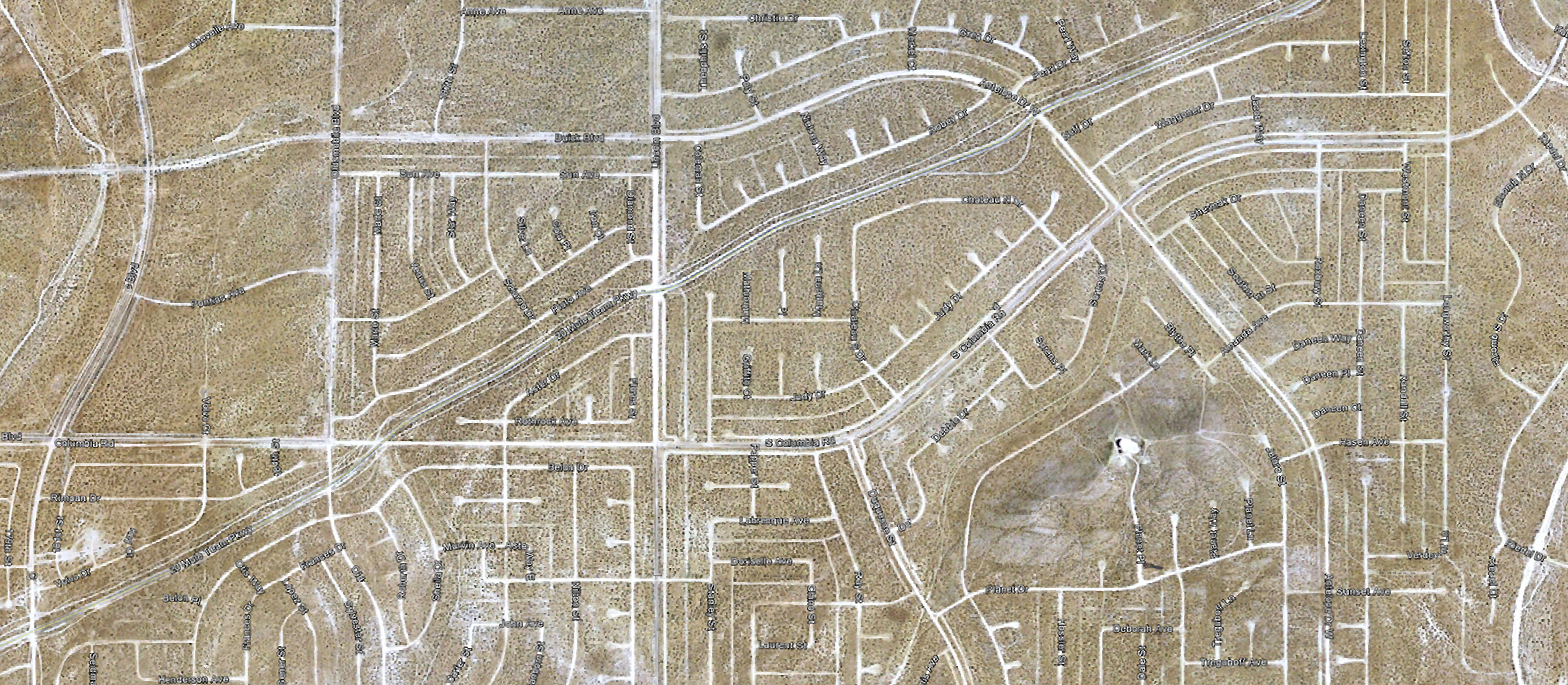
4b/5 - Urban Layout of named dirt-roads gridded into the desert -
California City, CA - [Screencapture (c) GoogleMaps]
California City, CA - [Screencapture (c) GoogleMaps]
[continued from page 4]
“(C) Vercye Ct, California City, CA
13. Head north on Vercye St toward Paul Ct
0.2 mi
14. Take the 3rd left onto Merrick Blvd 1.1 mi
15. Turn right onto Oldsmobile Blvd 0.3 mi
16. Take the 2nd left onto Belon Dr 0.2 mi
1.8 mi – about 8 mins
1.8 mi – about 8 mins
(D) Otis Way, California City, CA 93505
17. Head northeast on Belon Dr toward Oldsmobile Blvd
0.5 mi
18. Take the 2nd left onto Aster Dr 203 ft
19. Take the 1st right onto S Columbia Rd 0.3 mi
20. Take the 2nd left onto Griffith St 404 ft
21. Turn right onto Judy Dr 0.6 mi
22. Turn left onto Judy Ct 194 ft
1.5 mi – about 7 mins
1.5 mi – about 7 mins
(E) Judy Ct, California City, CA
23. Head southeast on Judy Ct toward Judy Dr
194 ft
24. Turn left onto Judy Dr 305 ft
25. Take the 1st right onto Chateau N Dr 344 ft
26. Turn left onto S Columbia Rd 0.6 mi
27. Turn right onto Westmont St 427 ft
0.8 mi – about 4 mins
0.8 mi – about 4 mins
(F) Amparo Way, California City, CA “

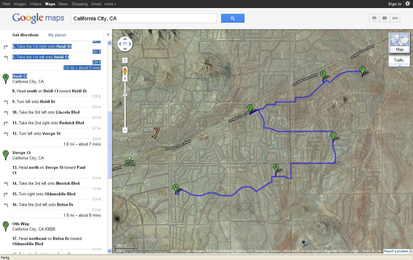
5/5 - Directions from Judy Wy to - Dr, via - Pl, - Ct, and - Ln
‚Downtown‘ California City, CA - Screencapture (c) GoogleMaps]
‚Downtown‘ California City, CA - Screencapture (c) GoogleMaps]
“CALIFORNIA CITY – Route 3
Get Directions
Note: Public transport coverage may not be available in this area.
Suggested routes
1. 0.6 mi, 3 mins
Judy Ln and Judy Dr
2. 11 mins
Or Walk
--
Driving directions to Judy Dr, California City, CA:
(A) Judy Way, California City, CA
1. Head southeast on Judy Way
171 ft
2. Turn left onto Judy Dr 295 ft
3. Take the 1st left onto Judy Pl 220 ft
0.1 mi – about 45 secs
0.1 mi – about 45 secs
(B) Judy Pl, California City, CA
4. Head southeast on Judy Pl
220 ft
5. Turn left onto Judy Dr 305 ft
6. Take the 1st left onto Judy Ct 194 ft
0.1 mi – about 46 secs
(C) Judy Ct, California City, CA
7. Head southeast on Judy Ct toward Judy Dr
194 ft
8. Turn right onto Judy Dr 0.2 mi
9. Take the 3rd right onto Judy Ln 171 ft
0.2 mi – about 1 min
0.2 mi – about 1 min
(D) Judy Ln, California City, CA
10. Head southeast on Judy Ln toward Judy Dr
171 ft
11. Turn right onto Judy Dr 312 ft
(E) Judy Dr, California City, CA
Save to My Maps
Which map do you want to save to? Save
<< Back
Ad
These directions are for planning purposes only. You may find that construction projects, traffic, weather, or other events may cause conditions to differ from the map results, and you should plan your route accordingly. You must obey all signs or notices regarding your route.
Map data ©2011 Google
Report a problem “